Humanitarian organizations and journalists have expressed concerns after a leading satellite imagery company told its users it was restricting access to images of Iran and large parts of the Middle East following a request from the US government.
California-based Planet Labs initially introduced a 14-day delay on providing new imagery from the region in March. It has since moved to an indefinite restriction.
The decision has limited how journalists, humanitarian groups, and analysts can use satellite images to assess the impact of the US-Israel war with Iran, including damage to military targets and civilian infrastructure.
It is unclear what prompted the US to press Planet to suspend its coverage, and the Department of Defense did not respond to a request for comment.
Planet initially said its original 14-day delay policy was to ensure our imagery is not tactically leveraged by adversarial actors to target allied and NATO-partner personnel and civilians.
It said in a statement to BBC Verify that it was now switching to a system of managed distribution and would share selected images on a one-off basis until the security risk has abated.
It declined to say how extensive the restrictions were. But based on BBC Verify's access to the portal, it appears to extend across most of the Middle East, including Iraq, Lebanon, Israel, and Gaza.
One satellite imaging expert told BBC Verify that companies like Planet that have military contracts can sometimes implement voluntary compliance requests that are actually driven by commercial incentive structures.
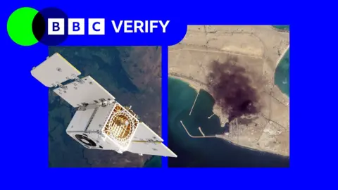
BBC Verify has used Planet imagery across the Middle East in its reporting, including since the war in Iran began at the end of February, such as when a US strike on a school in the Iranian town of Minab.
The changes now mean that images taken after March 9 are no longer routinely available to the company's clients.
Satellite imagery has become a key tool for reporters, according to investigative journalist Benjamin Strick, who has worked for CNN, the Financial Times, and the BBC, particularly in conflict zones, disasters, and other restricted environments where reporters cannot safely access the scene or where information is tightly controlled.
Planet's business model is similar to others in the industry. It has been expanding its work with the US defense sector, including the US National Geospatial Intelligence Agency and, through a subsidiary, the US Navy. It also works with the German and Swedish militaries.
Vantor, formerly known as Maxar, has contracts with the US Army and US Space Force and limits coverage of US military bases. However, it told Reuters earlier this week that it had not been asked by Pentagon officials to restrict its coverage of Iran.
Bill Greer, a geospatial analyst who previously worked at Maxar and co-founded the non-profit satellite service Common Space, noted that the number of defense contracts held by companies like Planet grants governments some degree of influence over them.
He also observed that humanitarian groups were affected by restrictions on satellite images. When an entire region goes dark indefinitely, it directly affects [their] ability to plan evacuations, assess damage, document human rights abuses and coordinate aid delivery, he said. This has been paralleled by concerns that bad actors have seized on these restrictions to proliferate fake imagery online.
Amir Farhand - founder of Soar.Atlas, an Australian mapping platform that uses satellite images - noted a massive spike in fake satellite imagery during this conflict, indicating a serious problem.
Ultimately, as new satellite providers emerge globally, restrictions like those requested of Planet may become more common, but may also prove increasingly futile in an era of democratized satellite technology.