In brief
An earthquake measuring 6.3 on the Richter scale hit northern Afghanistan near Mazar-e Sharif, leading to fears of significant casualties as residents fled buildings. The quake, occurring at a depth of 28 km, prompted reports of minor injuries from various districts, although a Taliban spokesperson warned of potentially greater impacts. Afghanistan's geographical location on tectonic fault lines puts it at continual risk for such disasters.
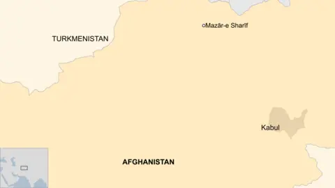
An earthquake has struck northern Afghanistan near Mazar-e Sharif, one of the country's largest cities around 20:30 GMT (01:00 local time).
The earthquake had a magnitude of 6.3 and a depth of 28km (17 miles), according to the US Geological Survey.
The agency also warned of significant casualties and potentially widespread disaster.
Writing in a post on X around 02:00 local time (21:30 GMT), a Taliban spokesman in Balkh, of which Mazar-e Sharif is the capital, said they had received reports of minor injuries and superficial damages from all districts of the province.
Most of the injuries were caused by people falling from tall buildings, he wrote.
Mazar-e Sharif is home to more than 500,000 people. Many of the city's residents rushed to the streets when the quake struck, as they feared their houses would collapse, AFP reported.
The Taliban spokesman in Balkh also posted a video on X appearing to show debris strewn across the ground at the Blue Mosque, a local landmark in Mazar-e Sharif.
The religious complex is believed to house the tomb of the first Shia Imam - a religious leader believed to hold divine knowledge. It's now a site where pilgrims gather to pray or celebrate religious events.
The quake on Monday comes after a 6.0 magnitude earthquake struck Afghanistan's mountainous eastern region in late August, killing more than 1,000 people.
Afghanistan is very prone to earthquakes because of its location on top of a number of fault lines where the Indian and Eurasian tectonic plates meet.