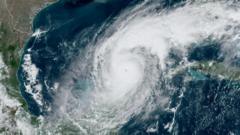
The U.S. Department of Defense (DoD) has temporarily reversed its decision to cut off access to vital satellite data necessary for monitoring hurricane behavior and forecasting. Initially slated to be halted by June 30, the crucial data will now remain available until July 31. This extension comes in light of significant concerns from meteorologists and climate scientists regarding the detrimental impact of the data loss on hurricane forecasts.
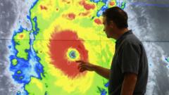
Last week, the National Atmospheric and Oceanic Administration (NOAA) had announced that data from three satellites, collaboratively managed by NOAA and the DoD, would no longer be accessible for researchers and forecasters due to "recent service changes" and cited a "significant cybersecurity risk" as justification for this decision.
The ultimatum had triggered widespread confusion and alarm among experts. Many pointed out that the loss of this data would sharply reduce the accuracy of hurricane forecasts, posing increased threats to communities in the U.S. and elsewhere. “The abrupt termination of this data access caught government forecasters off-guard,” said Michael Lowry, a recognized hurricane expert. He noted, “The extension merely delays urgent issues without addressing the critical hurricane months of August, September, and October."
The implications of this scenario extend beyond hurricane forecasting; the canceled data is also essential for climate research focused on the polar regions. Dr. Sharon Stammerjohn from the University of Colorado Boulder emphasized the importance of these records for monitoring sea ice changes in the Arctic and Antarctic since the 1970s. “The seasonal dynamics of sea ice are vital for understanding global climate,” she mentioned, referring to satellite imagery that tracks declines in polar sea ice, which plays a crucial role in reflecting solar energy back into space.
Although alternative satellite products from agencies like the European Space Agency and the Japan Aerospace Exploration Agency could potentially mitigate some of the data shortfall, variations in sensor calibration and data resolution pose significant challenges. The ongoing debate and uncertainty surrounding the satellite data availability highlights the critical intersection between national security decisions and the global climate emergency.