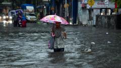
Tropical Cyclone Zelia made a dangerous landfall in northwestern Australia, prompting emergency measures as authorities warn of destructive winds and heavy rainfall that could impact essential ports and infrastructure.
Tropical Cyclone Zelia Strikes Northwest Australia with Intensity

Tropical Cyclone Zelia Strikes Northwest Australia with Intensity
Residents urged to seek shelter as the powerful storm brings high winds and heavy rain to critical economic regions.
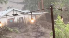
Tropical Cyclone Zelia made landfall on Friday afternoon near Port Hedland in northwestern Australia, unleashing destructive winds and heavy rainfall in a region vital for the global economy. The storm's winds reached speeds of up to 132 miles per hour, categorizing it as a strong Category 4 hurricane.
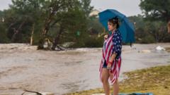
Official reports indicated that Zelia hit land around 12:30 p.m. local time, approximately 34 miles northeast of Port Hedland—a town in the Pilbara region, known for its extensive iron ore mining operations. As the cyclone approached, meteorologists warned of severe weather conditions, including intense rain and flash flooding, while predicting wind gusts that could reach an alarming 100 miles per hour throughout the area.
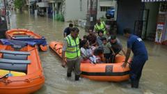
“Close to the eye of the storm, we anticipate even more severe winds of up to 180 miles per hour,” said meteorologist Miriam Bradbury from Australia's Bureau of Meteorology, highlighting the potential for catastrophic damage. Authorities quickly advised residents to stay indoors and secure their homes, closing schools and roads in flood-prone areas to prevent any injuries or fatalities.
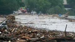
While Port Hedland was expected to miss the storm's most catastrophic center, it remained under a tropical cyclone warning covering from Wallal Downs to Roebourne, approximately 150 miles away. Key ports in the Pilbara, such as Dampier and Varanus Island, shut down operations in preparation for the storm, as they are crucial for iron ore and fuel supply chains.
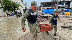
As Zelia is predicted to weaken after moving inland, the Bureau of Meteorology forecasts continued heavy rainfall in southern areas throughout the weekend. This situation serves as a reminder of the increasing intensity and frequency of cyclonic events linked to climate change and the imperative for communities to prepare for such extreme weather challenges.
Official reports indicated that Zelia hit land around 12:30 p.m. local time, approximately 34 miles northeast of Port Hedland—a town in the Pilbara region, known for its extensive iron ore mining operations. As the cyclone approached, meteorologists warned of severe weather conditions, including intense rain and flash flooding, while predicting wind gusts that could reach an alarming 100 miles per hour throughout the area.
“Close to the eye of the storm, we anticipate even more severe winds of up to 180 miles per hour,” said meteorologist Miriam Bradbury from Australia's Bureau of Meteorology, highlighting the potential for catastrophic damage. Authorities quickly advised residents to stay indoors and secure their homes, closing schools and roads in flood-prone areas to prevent any injuries or fatalities.
While Port Hedland was expected to miss the storm's most catastrophic center, it remained under a tropical cyclone warning covering from Wallal Downs to Roebourne, approximately 150 miles away. Key ports in the Pilbara, such as Dampier and Varanus Island, shut down operations in preparation for the storm, as they are crucial for iron ore and fuel supply chains.
As Zelia is predicted to weaken after moving inland, the Bureau of Meteorology forecasts continued heavy rainfall in southern areas throughout the weekend. This situation serves as a reminder of the increasing intensity and frequency of cyclonic events linked to climate change and the imperative for communities to prepare for such extreme weather challenges.