**Meteorologists warn of expansive risks as Hurricane Erin rapidly intensifies, with expectations of continued extreme weather in the coming days.**
**Hurricane Erin Ramps Up to Category Five, Foreboding Severe Weather Impact**
**Hurricane Erin Ramps Up to Category Five, Foreboding Severe Weather Impact**
**Powerful storm brings threats of intense rainfall and hazardous surf conditions along the Eastern US coast.**
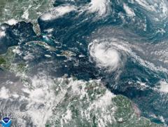
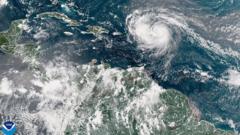
Hurricane Erin has rapidly escalated to a category five cyclone, boasting maximum sustained winds of 160 mph (260 km/h). According to National Hurricane Center Director Mike Brennan, this "extremely powerful" storm has "explosively deepened and intensified" overnight, transitioning from tropical storm status just a day prior. Erin is set to course north of the Leeward Islands, the Virgin Islands, and Puerto Rico during the weekend, bringing with it as much as 6 inches (15 cm) of rain—heightening the risks of flash floods and mudslides.
Having surged rapidly in intensity, Erin experienced a dramatic wind increase from 100 mph early Saturday morning to its current 160 mph strength. Meteorologists predict the storm will gradually progress northward next week, skirting the eastern part of the Bahamas and moving toward the Outer Banks of North Carolina.
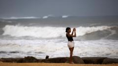
Brennan emphasized that the storm is generating life-threatening surf and rip currents expected to affect almost the entire East Coast of the United States in the upcoming week. Florida and mid-Atlantic states are poised to experience the most hazardous surf conditions, with Bermuda anticipating similarly dire weather including heavy rainfall and rough surf.
In light of the gale-force winds, the US Coast Guard has implemented restrictions for maritime vessels in ports across St. Thomas and St. John in the US Virgin Islands, along with six municipalities in Puerto Rico, including San Juan. The National Oceanic and Atmospheric Administration (NOAA) foresees an "above normal" Atlantic hurricane season this year, noting that global warming may lead to an increase in tropical storms reaching category four and five.

